Unfolded· 7 min read·9 September 2025
The Coast as a System
Lima to Paracas by helicopter — forty-five minutes at five hundred metres, the coastal geography read as a single continuous argument.
By Kada Travel Editorial
Lima to Paracas takes four hours by road on the Panamericana Sur — four hours during which the coastal desert outside the window is continuous, unchanging, and entirely unavailable for the kind of attention a highway at eighty kilometres per hour discourages. The helicopter takes forty-five minutes at five hundred metres, and the same coastal desert seen from above is a different subject entirely: not a monotonous edge but a geographical system, fully visible in its logic for the first time.
We offer this route when the itinerary requires it and the geography rewards it. Neither condition is always present. This article explains both.
The Geography at Five Hundred Metres
The coastal desert between Lima and Paracas is one of the driest environments on earth — an extension of the Atacama that runs along Peru's Pacific coast from the Chilean border north through Arequipa, Ica, and Lima, where the Humboldt Current's cold upwelling suppresses precipitation and keeps the land that faces it in perpetual aridity. At road level, the desert presents itself as a flat brown plain occasionally interrupted by the coastal cliffs, the fishing towns below them, and the river valleys that cross it perpendicularly on their way from the Andes to the sea. At five hundred metres, the system becomes legible.
The Panamericana follows the coastal plain; from above, it reads as a thin grey line marking the inland boundary of the cliff zone. The cliffs themselves — the coastal escarpment that the Pacific has been cutting into for millennia — face directly west to the Humboldt Current and drop between fifty and two hundred metres to the beach below. The beaches are not tourist beaches; they are the working coast — fishing boats anchored in the bays below small towns, nets laid out to dry on the flat rock, the boats of the artisanal fleet returning from the night's fishing in the same cold water that supplies Lima's ceviches.
The fishing towns themselves — Pucusana, Chilca, Cerro Azul, San Andrés — are visible from altitude as clusters of low structures in the bays where the cliff breaks and the coast gentles enough for a harbour. From the road, each town is a thirty-second passage. From five hundred metres, the relationship between the town, its bay, its boats, and the coastal geometry that explains why a community is there at all — that question of why here rather than five kilometres north or south — becomes visible in the time it takes to pass over them.
The river valleys appear in sequence: the Cañete, the Chincha, the Ica — dark green bands cutting through the pale desert where Andean snowmelt reaches the coast and creates the microenvironments in which Peru's coastal agriculture has existed for millennia. The Ica Valley, visible forty minutes into the flight, is the pisco-producing region: the vineyards that supply the five grape varieties of Peru's Denominación de Origen grow in the irrigated floor of the valley, invisible from altitude but contextualised by the desert that makes their water so consequential.
The Arrival at Paracas
The Paracas National Reserve extends south from the town — a protected zone of coastal desert, sea cliffs, and the shallow bay that shelters the Paracas Peninsula. From above on the descent, the reserve's character is immediately apparent: the coast here is not the working coast of the fishing towns to the north but a different register of the same landscape, less inhabited and more geological.
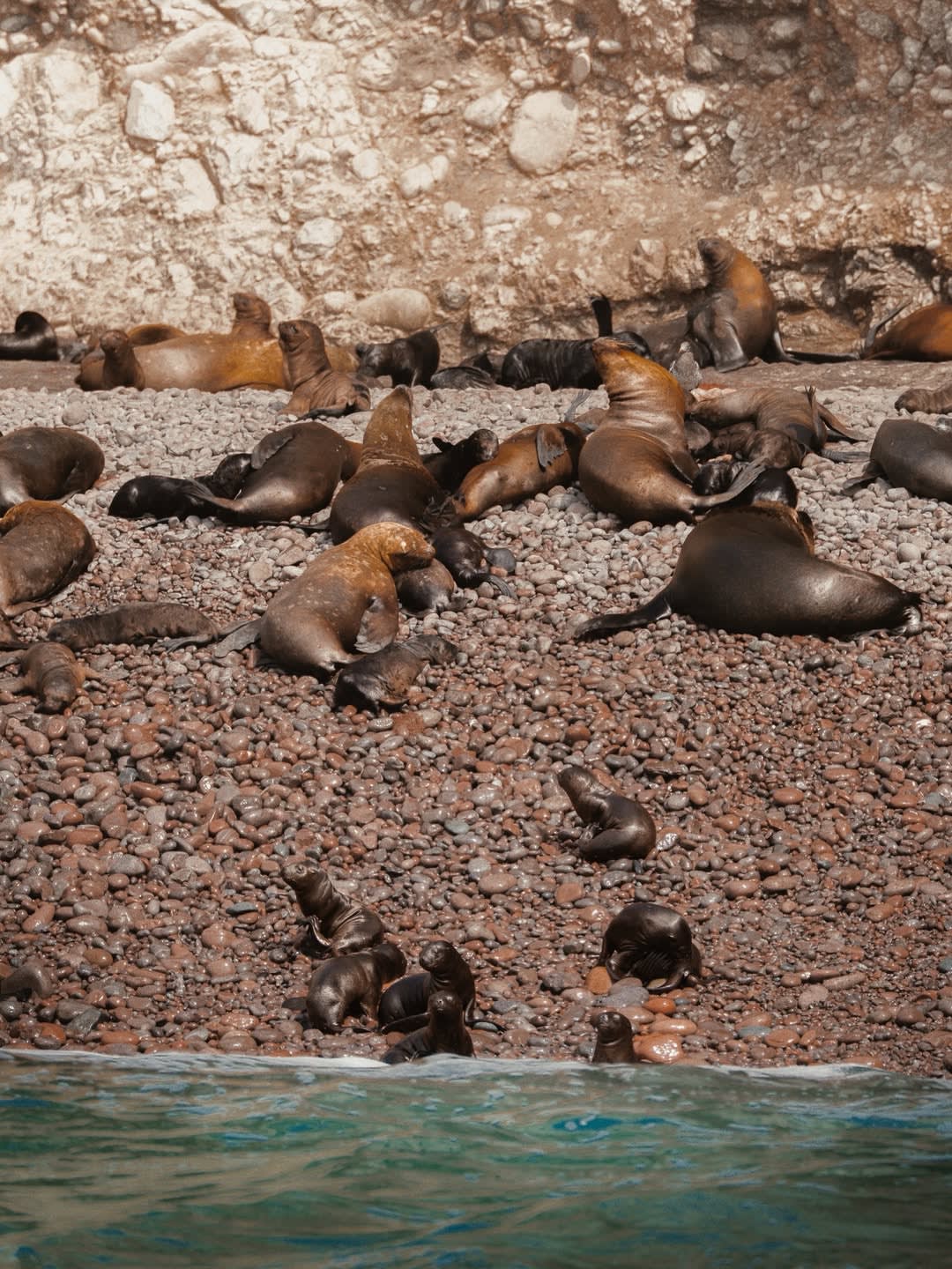
The Ballestas Islands — a cluster of rocky outcroppings ten kilometres offshore from the Paracas bay — are visible from altitude before the landing. At sea level, the Ballestas require a boat trip and binoculars; at five hundred metres on the descent, the islands and their resident sea lion colonies are legible as a geography rather than as a wildlife sighting. The Humboldt penguin rookeries on the island's southern faces are not individually visible from altitude, but the islands themselves — the reason the reserve exists, the reason the fishing in this bay has been protected — are positioned in the context of the coast that produced them.
Landing near Paracas, after forty-five minutes of coastal geography, the traveller arrives with a spatial understanding of what the reserve is situated in — the full coastal system read from north to south — that no car arrival on the Panamericana provides.
When the Helicopter Makes Sense
The helicopter route between Lima and Paracas makes sense in two circumstances.
The first is the constrained itinerary: guests with five days in Peru who want Lima, Paracas, and Cusco cannot spend eight hours of it driving to and from the coast. For these guests, the helicopter recovers three and a quarter hours of each Paracas direction and allows the itinerary to function at a pace the road does not permit.
The second is the guest whose interest in the coastal geography extends beyond what a beach excursion provides — guests who want to understand Peru's Pacific coast as a system, who find the relationship between the Humboldt Current, the fishing economy, and the coastal desert more interesting from above than it is from the road. For these guests, the flight is not a time-saving mechanism; it is the experience itself.
We are equally direct about when the helicopter does not make sense: for guests with a week or more in Lima and Paracas, the road down the Panamericana — with stops at Pucusana for a seafood lunch on the dock and at the Chincha region for a brief encounter with the Afro-Peruvian heartland — is a different and equally valuable journey. The road reveals what the altitude cannot: the working texture of the coast at human scale.
One restriction we address directly: helicopter access to the Machu Picchu area is not offered. Peru's Dirección General de Aeronáutica Civil (DGAC) restricts civilian helicopter operations in the Cusco and Machu Picchu zones to emergency and authorised institutional use. Any operator offering helicopter access to Machu Picchu is operating outside this framework. We do not offer it, and we note the restriction when guests ask.
What Kada Arranges
The Lima-to-Paracas helicopter transfer is arranged through a certified Peruvian aviation operator with current DGAC authorisation, comprehensive insurance, and an experienced crew. The flight uses a certified turbine helicopter with a capacity of four to six passengers depending on the aircraft deployed; the specific aircraft is confirmed at the time of booking based on group size.
We handle the logistics — the departure point in Lima (confirmed based on the guest's hotel location and airspace clearances), the weight and baggage declaration required for the flight manifest, and the ground transportation at the Paracas end. The transfer door-to-door typically runs sixty to seventy-five minutes from hotel departure to the Paracas accommodation, versus four to five hours by road depending on traffic leaving Lima.
The flight is weather-dependent. Lima's coastal fog (garúa) occasionally requires delayed departure in the early morning hours; afternoon departures typically face fewer weather variables. We confirm the departure window with the operator forty-eight hours in advance and communicate any adjustment to our guests' itinerary accordingly.
Expert Insight
"I have put guests in this helicopter and then met them at the Paracas end, and the conversation is always about what they saw on the way rather than about arriving faster. The fishing boats below Pucusana. The vineyards in the Ica Valley. The Ballestas visible offshore before they'd even landed. They were not expecting to see Peru's coast as a complete thing — most people never do. The helicopter gives them the geography as a single sentence rather than as disconnected paragraphs."
— Gustavo Arenas, Guest Relations, KADA Travel
A Practical Note
The helicopter requires a weight and baggage assessment for the flight manifest. We request this information at booking — passenger weights and luggage specifications — so the operator can confirm the aircraft and the load calculation. For guests with large luggage volumes, we arrange ground transport of excess baggage via road to meet the helicopter at Paracas, which is both logistically cleaner and more comfortable for the flight.
The noise level inside the helicopter requires communication headsets, which are standard equipment on all flights. The flight is not silent in the way that paragliding is silent; it is contained and loud in the way that a small aircraft is loud, with the view as the compensation. Guests who are sensitive to noise or enclosed spaces should discuss this with us before booking.
Written by Kada Travel Editorial
Frequently Asked
The Lima-to-Paracas route is the primary fixed-wing helicopter transfer we offer. Other coastal routes — Lima to Chincha, Lima to Ica — are arrangeable depending on operator availability and landing clearances. For guests with specific logistical needs elsewhere in Peru, we assess availability case by case. We do not offer helicopter transfers to Machu Picchu or the Cusco region, for the DGAC reasons noted above.
The Nazca Lines are accessible by small fixed-wing aircraft from the Nazca or Ica airports — a standard and well-operated overflight route. The helicopter we deploy for the Lima-Paracas transfer is not the right aircraft for a Nazca overflight (different altitude, different duration, different operational approval). We arrange Nazca Lines overflights separately, as part of an Ica or Nazca leg of the itinerary.
We rebook on the next viable departure window and arrange ground transport as an immediate backup so the Paracas portion of the itinerary is not lost. The ground transport option — with driver and a scheduled stop at Pucusana for lunch — is not a failure mode. For some guests, the weather cancellation produces the better journey.
We book the aircraft two to three weeks in advance for standard dates and up to six weeks in advance for peak season (July-August, December-January). Same-week bookings are occasionally possible depending on operator availability; we always attempt to accommodate late-notice requests but cannot guarantee aircraft availability.
Design Your Journey
Design your bespoke Peru journey
We talk. We listen. Then we design an itinerary that belongs only to you.
Start Planning