Unfolded· 7 min read·6 September 2026
The Hour That Rewrites the Distance
Helicopter access on the Lima–Paracas–Ica–Nazca corridor — forty-five minutes over the Pacific coastal desert from Lima to Paracas, with the reserve peninsula, the Ica valley oasis, and the Nazca pampa visible as a unified geographical system at altitude, with a DGAC-certified operator on a coastal route with no airspace restrictions.
By Kada Travel Editorial
The Pan-American Highway from Lima to Paracas covers two hundred and fifty kilometres of coastal desert in approximately four hours. The road is fine; Peru's southern highway is among the better-maintained stretches of the Pan-American system, and the desert scenery between Lima and Pisco has a specific austere quality that is worth experiencing once. The problem with the road is not the road. It is the perspective: at ground level, the coastal desert is a series of adjacent sections, each one seen through the windshield in sequence, with the geography of the whole — the Humboldt Current coastline, the Ica valley oasis set into the desert, the Nazca pampa in its true extent — unavailable until after the fact.
From a helicopter at a hundred metres above the Pacific coast, the geography is a single sentence. The road occupies one narrow margin of it.
The helicopter departure from Lima is a forty-five-minute flight south along the coast to Paracas. In those forty-five minutes, the following is visible as a continuous image: the desert bluffs of the Lima shore dropping south toward Lurín, the Pan-American Highway as a thin line beside the coast, the first dunes of the Ica system beginning south of Cañete, the Paracas peninsula coming into view as a red-rock headland reaching into the grey Pacific, the outline of the Ballestas Islands offshore, and — depending on the flight route — the northern edge of the Paracas Marine Reserve. The Ica valley: an island of green agriculture set into brown desert, fed by the Ica River running west from the Andes, the oasis of Huacachina visible as a small dark oval surrounded by white dunes before the green ends and the desert resumes. South of Ica: the Pampa Colorada begins, and the Nazca Lines — if the flight extends to Nazca — are the final element: the same geometry that the Cessna shows at three hundred metres, now visible at a different altitude and in full landscape context.
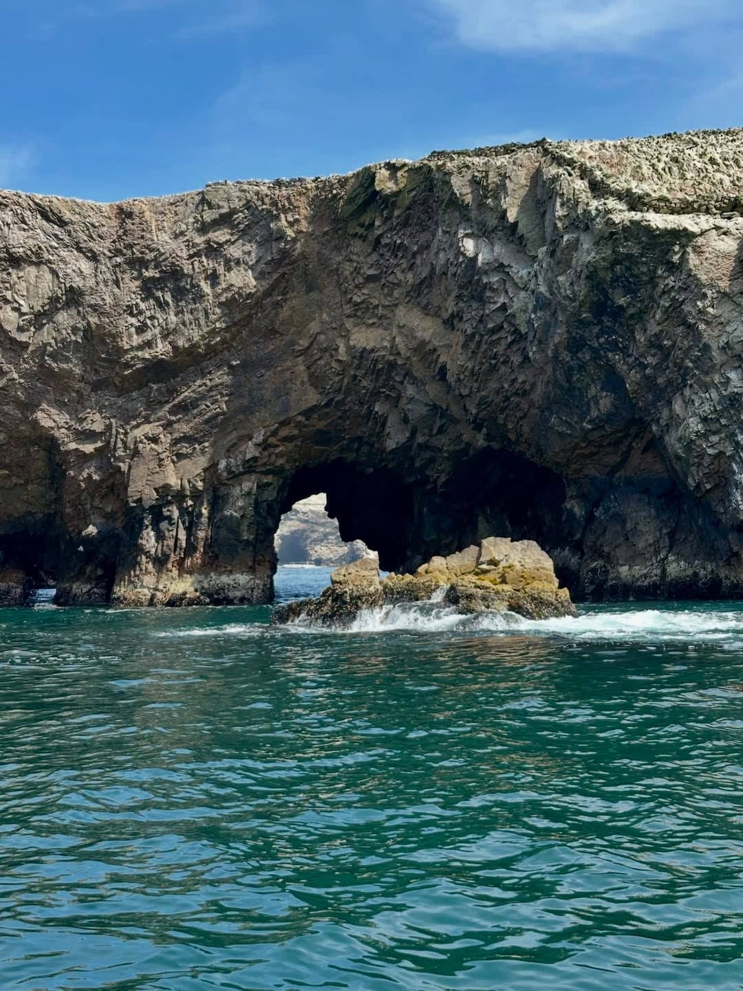
The Lima-Paracas Corridor
The coast between Lima and Paracas is one of the cleanest illustrations of the Humboldt Current's influence on Peruvian geography. From the air, the Pacific's colour changes are visible: the cold upwelling water runs grey-green close to shore, the lighter surface colour of the upwelling zone distinguishable from the deeper blue of the offshore water. The desert runs directly to the clifftop edge; there is almost no beach at the base of the bluffs for long stretches of the coast. The dry riverbeds — the quebradas — cut at right angles from the inland hills to the ocean, marking the rare occasions when water reaches the coast from the Andes. The Pan-American threads between the coastal bluff geometry and the inland desert, occasionally disappearing into tunnels and re-emerging on bridges.
The Paracas peninsula from altitude is the visual culmination of the corridor: the red-rock headland extending westward into the Pacific, the reserve visible as the undeveloped coastal zone, the Ballestas Islands as grey rocks offshore surrounded by the lighter green-grey of the shallower water. The Candelabro geoglyph is visible on the northern headland — from this altitude, the figure reads differently again, at a scale between the Cessna view over Nazca and the ground view from the reserve road. The helicopter passes it on the descent toward the Paracas landing zone.
There is no ground-level equivalent of this reading. The coastal desert, the Humboldt upwelling, the reserve, the geoglyph, and the Ballestas are each individually accessible by road and boat. What the corridor flight provides is the system: the evidence that these are not separate items on a Paracas itinerary but a single continuous geographical argument. Most guests who have already taken the road to Paracas and the boat to the Ballestas recognise, in the helicopter view, that they had the elements but not the sentence.
The Ica Valley From Above
The Ica valley is the most dramatic visual element of the Lima-Nazca flight. From the ground, the oasis at Huacachina — the small lake at the centre of a bowl of dunes, the only natural desert oasis in South America — is striking; from the air, its context is extraordinary. The green agriculture of the Ica valley floor — asparagus fields, vineyard rows, orchards, the rectangular geometry of irrigated plots — ends with complete precision at the desert margin. There is no gradient, no transitional zone; the irrigation boundary is an absolute line. On one side: agriculture that could be Provençal in its order and density. On the other: the Atacama system desert that runs south to Chile.
The Huacachina dunes — white-sand formations up to a hundred metres high, shaped by prevailing winds into the sinuous crests visible from considerable altitude — are a distinct visual register from the brown Nazca pampa further south. The oasis lake at their centre is surrounded by the small hotel and restaurant district that serves the sandboarding and 4x4 dune tourism; from the air, at the scale of the dune field, the human settlement reads as small and impermanent against the dune geometry.
The bodegas and vineyard properties of the valley are visible in their field patterns from altitude — the vine-row geometry of a working estate, identifiable by its parallel linear structure and spacing, distinguishable from the row crops by orientation. The Ica valley wine and pisco production is not typically visible from the ground unless one is inside a specific estate; from the helicopter, the valley's agricultural system reads as a coherent whole in its desert context.
The value of this view is not scenic. It is contextual: the ground programme that follows — the pisco route through the bodegas, the Tacama hacienda, the Huacachina dunes — takes place inside a system that from the air is legible as a whole. The guest who has seen the Ica valley from altitude arrives at the bodega with a different kind of attention than the guest who arrives having read the dossier.
The Nazca Lines From This Altitude
If the flight extends to Nazca — as a full Lima-Nazca corridor programme, or as a one-way positioning flight before a Cessna overflight from the María Reiche aerodrome — the Pampa Colorada becomes visible south of Palpa as the ochre-coloured flat surface extending for kilometres without topographic interruption. From helicopter transit altitude, the principal Nazca Lines are not at the optimal viewing angle — the Cessna at three hundred metres is the correct altitude for reading the individual biomorphic figures; the helicopter provides the landscape-scale view of the pampa as a whole, which the Cessna, focused on individual figures within its circuit, does not give.
The combination programme — helicopter south to the Nazca aerodrome, transfer to Cessna for the figure-reading overflight at correct altitude, helicopter or road return — gives both readings of the same landscape: the helicopter's landscape scale and the Cessna's figure-reading intimacy. This is the version Kada recommends for guests dedicating a full day to Nazca from Lima, since the positioning flight over the coastal corridor is itself a substantive geographical argument rather than merely a faster transit.
No Airspace Restrictions
The significant operational difference between the Lima-Paracas coastal helicopter corridor and the Cusco Southern Andes helicopter programme is the absence of airspace restrictions. The Ministerio de Cultura's prohibition on low-altitude helicopter overflight and landing at Machu Picchu — the constraint that defines and limits what the Cusco programme can offer — has no parallel on the coastal corridor. The Paracas Reserve, the Ica valley, the Nazca pampa, and the corridor between Lima and Nazca are accessible to DGAC-certified commercial helicopter operations without exceptional permit requirements.
This is worth stating plainly because it affects what is possible. The Lima-Paracas programme can be designed as a direct positioning flight for guests whose itinerary prioritises time at the destination over the road journey. It can be designed as a scenic overflight with intermediate stops. It can include the Ballestas Islands from above on the outbound leg. It can serve as a return from Nazca after three days in the Paracas/Ica/Nazca region, with the northern coastal geography seen on the flight home. The programme adapts to the itinerary rather than defining its terms.
What Kada Arranges
The pilot Kada works with on the Lima-Paracas corridor is not a charter sourced by request. He has been flying this coastline commercially for over a decade — long enough that the coastal geography is not a route he navigates but a landscape he knows how to give. He reads the Humboldt fog patterns that close the Lima coast in winter mornings: when to depart, when to wait, when the marine layer will have cleared Paracas before it clears Lima. He knows the approach angles at which the Paracas peninsula, the Ica valley's irrigation margin, and the Nazca pampa are most legible from altitude — not from the instrument panel but from twelve years of flying the same corridor in every seasonal light condition. At Cruz del Candelabro on the northern Paracas headland, the altitude that resolves the geoglyph figure is not the altitude the corridor normally transits; he adjusts. DGAC certification is the regulatory floor for commercial passenger operations. What this operator brings to the programme is accumulated judgement about what this specific coastal geography shows, and the sequence in which it lands.
Programme configurations:
Lima to Paracas transfer: forty-five-minute positioning flight, arriving in Paracas in time for the reserve programme or the following day's Ballestas departure; eliminates the four-hour road journey on one leg of the itinerary.
Lima-Paracas-Ica scenic corridor: extended coastal flight covering the reserve peninsula, the Ica valley, and Huacachina before landing at Ica; continues to Paracas by road or continues to Nazca by helicopter or vehicle.
Full Lima-Nazca overflight: the complete southern coastal geography from Lima to the Nazca pampa as a single aerial traverse, with intermediate stops at Paracas and Ica landing zones as the itinerary requires. Recommended for guests who want the geographical argument in full before entering the individual programmes on the ground.
Return positioning: clients who have completed the Nazca/Paracas itinerary can return to Lima by helicopter rather than road, with the overflight in reverse and the northern coastal geography serving as the visual close to the southern circuit.
Expert Perspective
"The question with the helicopter for Paracas is different from Cusco. In Cusco, the helicopter is access — it gets you to Choquequirao or Vinicunca, places the road cannot reach in a day. In Paracas, it is orientation. You can drive to Paracas; the road is fine. What you cannot do on the road is see the coastal system as a system — the way the desert, the reserve, the Ica valley, and the Nazca pampa relate to each other spatially. I have driven that road more times than I can count, and I have taken the helicopter perhaps fifteen times, and I can tell you that my understanding of what we are offering in the Paracas and Nazca programmes is substantially different from the air. It is not a luxury convenience. It is a different reading of the geography we work in."
— Gustavo Arenas, Guest Relations, KADA Travel
A Practical Note
Weather on the coastal route: the Lima-Paracas corridor operates over low-altitude terrain without the high-altitude thermal complexity of the Cusco programmes. The primary weather variable on this route is coastal fog — the garúa — which affects Lima and the coast between Lima and Paracas in the austral winter (May-November). The pilot assesses visibility conditions on the morning of the flight; if coastal fog is thick enough to preclude visual flight rules operation, the flight is rescheduled. This is more common in winter than in summer; Kada communicates the seasonal fog probability at booking.
Motion: the coastal helicopter route at lower altitudes has less thermal turbulence than the Cusco highland programmes. Coastal air in the afternoon produces some swell over the bluffs and the desert. Morning departures from Lima are recommended for the smoothest conditions and the best morning light over the coastal formations.
Aircraft capacity: the standard helicopter configuration accommodates four to five passengers. The full Lima-Nazca overflight is a longer-duration flight; the operator provides the comfort briefing at booking. Larger groups require multiple aircraft or a split programme, which Kada designs as part of the logistics.
Landing logistics: the Paracas hotel area and the Ica zone have established helicopter landing points; the Nazca aerodrome accommodates helicopter arrivals. Kada coordinates the full chain from Lima departure to destination arrival, including ground transport from the landing zone.
Written by Kada Travel Editorial
Frequently Asked
No. The helicopter corridor in this programme runs along the Pacific coastal desert south of Lima. The Cusco region helicopter programme is a separate product for the Southern Andes, and the Machu Picchu archaeological sanctuary is regulated against helicopter overflight and landing. The coastal route has no equivalent airspace restrictions, which is what makes it operationally straightforward in a way that Machu Picchu access is not.
Yes. The most common configuration for guests who want the aerial perspective without doubling the flight time is to fly one direction and return by road. Lima-to-Paracas by helicopter and Paracas-to-Lima by road is a standard arrangement; so is arriving at Paracas by road after overnight from Lima and returning by helicopter after the reserve and Ballestas programmes are complete. Kada manages the vehicle logistics for the ground leg in either direction.
If the flight extends south to Nazca, the Pampa Colorada and the Lines are visible from transit altitude. The helicopter is not the optimal viewing altitude for reading the individual Nasca figures — that requires the Cessna at three hundred metres. Kada designs the combination programme to include both: helicopter transit to Nazca aerodrome for the landscape scale, then Cessna overflight for the figure-reading altitude.
Most effectively as the inbound leg — flying Lima to Paracas on day one, with the coastal corridor giving geographical context before the ground programmes begin. Returning by road on the final day allows the drive through the same landscape that was seen from above, which most guests find confirming rather than redundant. The road on the return is four hours of desert landscape that now has context; it is a different experience than the same road without the aerial preparation.
Design Your Journey
Design your bespoke Peru journey
We talk. We listen. Then we design an itinerary that belongs only to you.
Start Planning