Unfolded· 8 min read·1 September 2026
The Map No One on the Ground Can Read
Private Cessna 207 flight over the Nazca Lines from the airport bearing María Reiche's name — with an academic briefing that sets the Reiche legacy as the interpretive frame, not the tourist circuit, so that the figures visible from three hundred metres become legible rather than merely visible.
By Kada Travel Editorial
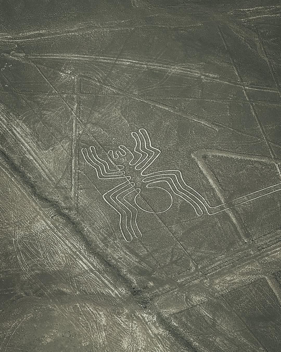
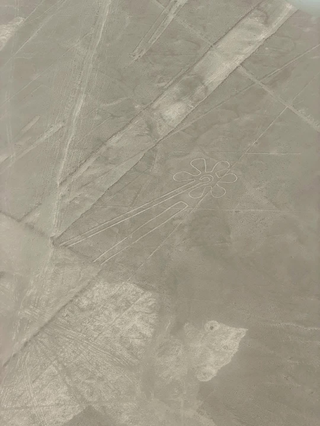
The Nazca Lines occupy 450 square kilometres of coastal pampa in southern Peru, and from the ground they are almost nothing. The desert surface of reddish-brown iron oxide pebbles is interrupted in places by pale lines — lighter rock exposed by the deliberate clearing of the darker surface material — but the pattern they form is not legible from any terrestrial vantage point. A single line can run straight for forty kilometres over terrain that is not flat; the geometric figures — the spider, the hummingbird, the monkey, the condor, the whale — range from forty-six to nearly one hundred metres in length. They are, architecturally, impossible to read from within them.
This is the first and most essential fact about the Nazca Lines, and it is the fact that separates two fundamentally different encounters with them. The standard Nazca experience is a flight of thirty to thirty-five minutes in a light aircraft, lifting off from the airfield bearing María Reiche's name and returning after a circuit of the principal figures. In that version, the lines are a spectacle — remarkable, strange, photographed. The Kada version adds what the standard circuit removes: the interpretive frame that makes the figures readable rather than merely visible.
That frame is Reiche's. María Reiche, a German mathematician who arrived in Nazca in 1940 and spent the next fifty-eight years mapping, measuring, and protecting the lines, is the person through whose intellectual work the Nazca figures became an object of serious international inquiry rather than a regional curiosity. She flew the lines in a Cessna from the 1940s onward; she produced the systematic cartographic documentation that remains the baseline for current research; she slept beside the figures to prevent their destruction at a time when the Peruvian road-building programme had already eliminated several. The airport that now serves as the departure point for tourist flights carries her name — a fact most visitors notice without registering what it means.
The Pampa and Its Scale
The Nazca pampa is technically called the Pampa Colorada — the red pampa — for the iron oxide crust that gives the undisturbed desert its characteristic rust colour. The lines are made by negative relief: the Nasca culture removed the top layer of reddish pebbles along the desired paths, revealing the pale yellow-grey substrate beneath. The simplicity of the technique is part of what makes the lines astonishing: there is no engineering in the materials themselves, no construction, no building. What the Nasca created is a vast act of subtraction — taking the surface away in patterns of extraordinary precision.
The precision is the harder thing to account for. A single straight line at Nazca can run forty-three kilometres over hills, ravines, and uneven ground without deviating in a way that would be visible from the air. The trapezoids and rectangles cover areas the size of airport runways; the spiral forms turn without the gradual drift that would result from measurement error at ground level. The figures — biomorphic forms including the spider, monkey, and hummingbird, but also a dog, a whale, a pair of hands, a tree, a lizard — were executed in single, unbroken lines that do not cross themselves. From the ground, this is impossible to verify. From a Cessna at three hundred metres, it is simply visible.
The culture that created them — the Nasca, active in this region between approximately 200 BCE and 600 CE — also built Cahuachi, the ceremonial complex twenty-eight kilometres west of the modern town of Nazca, and buried their dead at Chauchilla, the necropolis thirty kilometres south. The three sites form a triangle of Nasca cultural geography that the Lines anchor as its most visible and least understood element.
The Function the Lines Served
The question of what the Nazca Lines are for is, academically, still open. Reiche argued for an astronomical calendar — the lines as alignments pointing to solstice and equinox sunrises and sunsets, the figures encoding astronomical information. Subsequent work by archaeoastronomers partially confirmed and partially complicated this thesis: some alignments are statistically significant against a random baseline, but not all, and the sheer density of overlapping lines in some areas suggests accumulation over centuries rather than a single designed system.
More recent scholarship, drawing on the relationship between the lines and the hydrology of the pampa, proposes that many of the straight lines follow subterranean water sources — that the Nasca, who created remarkable underground aqueducts (the puquios) to manage water in one of the world's driest environments, mapped their water infrastructure in geoglyphs. In this reading, walking a line was a ritual act of water invocation; the figures are devotional objects in a landscape-scale ceremonial system whose audience was not human and not necessarily aerial.
None of these interpretations is settled. The briefing Kada provides before the flight is explicit about this: what is known is secure; what is inferred is identified as inference; what is unknown is named as unknown. The figures are not made more interesting by false certainty, and Reiche's own intellectual discipline — she spent decades saying what she could prove and distinguishing it carefully from what she suspected — is the model.
The Reiche Method
Reiche arrived in Lima from Germany in 1932 as a governess and translator. Her encounter with the Nazca Lines came through the mathematician Paul Kosok, who was studying ancient irrigation systems in Peru and needed a German-speaking assistant. When she first saw Kosok's aerial photographs of the pampa, she recognised the mathematical patterns and devoted the following six decades of her life to documenting them.
Her method was systematic and physical. Working largely alone in the pampa from the 1940s to the 1970s, she mapped the lines by hand, measured their geometry, and catalogued the figures with a precision that remained the definitive cartographic record until satellite imaging became available. She swept the lines with a broom to keep them clear of encroaching sand — a practice that strikes modern conservation archaeologists as problematic but that, in the context of the 1950s, was the only available means of maintenance. She lobbied the Peruvian government and international institutions for the Lines' protection; the UNESCO World Heritage inscription in 1994 came twenty-seven years after her first official petition.
The Aeródromo María Reiche Neuman is the departure point for commercial overflights of the Lines. Kada's programme begins the afternoon before the flight at the small museum maintained in her house in Nazca, where the guide's preparation in the Reiche archive — her notebooks, her cartographic sheets, her published papers — provides the briefing that the flight makes use of the following morning.
The Flight Itself
The aircraft Kada uses for the Nazca overflight is a Cessna 207, the same general type that Reiche herself flew in her decades of documentation work. The circuit covers the principal figures of the southern pampa in a standard pass of approximately thirty to thirty-five minutes; an extended circuit adding the northern pampa — including the astronaut figure on the hillside and the hands — adds fifteen minutes.
The flight is private: one aircraft, one group of maximum five passengers, two pilots. There is no shared aircraft, no guide with a microphone repeating the standard sequence of announced figures. The pre-flight briefing replaces the in-flight narration; the flight itself proceeds in a silence interrupted only when the co-pilot or the guest asks a question.
The thermal turbulence of the Nazca pampa is real and significant. The desert heats rapidly after nine in the morning; the thermal activity above the pampa creates the rolling turbulence that the Cessna's small frame transmits directly. Kada schedules Nazca overflights for early morning departure — ideally wheels up before eight — both to capture the smoother air and to see the figures when the low-angle morning light creates the strongest contrast between the pale lines and the rust-coloured surface.
What Kada Arranges
The programme begins the afternoon before the flight at the Museo María Reiche in Nazca — the house where Reiche lived and worked — for a one-hour briefing with a guide whose preparation in the Reiche archive goes beyond the standard circuit. The briefing covers Reiche's cartographic methodology, the current state of scholarly interpretation, and the specific figures the circuit will cover, so that the flight is a recognition rather than a discovery.
The morning of the flight: private vehicle from the hotel to the airfield, pre-flight weight assessment (the Cessna's seat load parameters are specific; Kada communicates them at booking), departure. Kada coordinates with the operator on the flight window and adjusts departure time if morning conditions warrant.
Post-flight debrief is optional but offered: a thirty-minute conversation with the guide over breakfast to review what was seen and address questions that arose in the air. This is where the water hypothesis, the astronomical calendar thesis, and the relationship between the Lines and Cahuachi typically find their fullest treatment.
Kada designs the Nazca visit as a three-site programme over two days: the Lines overflight, Chauchilla with an archaeologist, and Cahuachi with a specialist connected to the Italian research mission. The three-site sequence gives the Nasca culture its full geography — aerial, mortuary, and ceremonial — rather than the single-day circuit that compresses all three into an insufficient schedule.
Expert Perspective
"The mistake most people make at Nazca is thinking the flight is the experience. The flight is the vantage point. The experience is what you bring to it — what you know about what you're looking at before you get in the plane. I've done this flight more times than I can count, and I still find it different every time I've done a proper briefing beforehand compared to arriving at the airport and taking off with nothing. What Reiche understood — and what took the rest of the world decades to appreciate — was that the lines require intellectual preparation that the pampa itself cannot provide. You have to bring the context. The pampa provides the geometry."
— Jaime Ttito, Head of Guides & Cultural Interpreter, KADA Travel
A Practical Note
Altitude: Nazca sits at approximately 588 metres above sea level. Altitude acclimatisation is not a factor. Guests arriving directly from Lima or flying in from Cusco face no physiological adjustment requirement.
Motion: the thermal turbulence above the Nazca pampa is the most consistent physical challenge of the experience. The Cessna 207 is a small aircraft, and the rolling, updraft-driven motion of the late-morning thermals is significant — not dangerous, but noticeable and sustained. Guests with a history of motion sensitivity in light aircraft should communicate this at booking so that the earliest possible departure window can be reserved. Medication options are worth discussing with a physician beforehand for guests with strong susceptibility.
Season: Nazca is one of the driest environments on earth — less than four millimetres of annual rainfall — and the lines are accessible year-round in terms of weather. The practical seasonal variable is thermal activity. The dry austral winter (May through October) produces the most stable morning conditions. Year-round access is standard; the early morning departure recommendation intensifies in the summer months.
Weight: the Cessna 207 has per-seat weight parameters that affect the aircraft's load balance. Kada requests weight information at booking and communicates any constraints that affect seating configuration before arrival at the airfield.
Written by Kada Travel Editorial
Frequently Asked
The Cessna 207 has per-seat weight parameters that affect the aircraft's load balance; the specific limits vary by operator and configuration. Kada communicates the exact parameters at booking. Guests near or above the standard parameters should discuss this in advance rather than at the airfield — the conversation is logistical, and there are generally options including seat reassignment or aircraft configuration adjustment.
The Nazca overflight has a commercial aviation history with a documented safety record. The two-pilot operation standard at Nazca — both pilots in the cockpit for every commercial passenger flight — is a protocol adopted industry-wide. The operator Kada uses holds DGAC commercial aviation certification and current insurance. The thermal turbulence of the pampa is a routine operational condition that pilots on this route manage as a standard feature of the flight, not an exception.
There is a metal viewing tower on the Pan-American Highway that offers a vantage point above the desert surface. From it, two or three simple geometric figures are partially legible. The biomorphic figures — the spider, the monkey, the hummingbird — cannot be read from ground or tower; they require altitude. Kada includes the tower as an orientation visit the afternoon before the flight, not as a substitute for the aerial view.
The three principal Nasca sites — the Lines, Chauchilla, and Cahuachi — are each distinct programmes. Kada designs the Nasca itinerary as a multi-day sequence incorporating all three; combining the overflight with a Chauchilla visit in a single full day is the most common request. The Cahuachi programme typically occupies a separate half-day.
Design Your Journey
Design your bespoke Peru journey
We talk. We listen. Then we design an itinerary that belongs only to you.
Start Planning